
Week 10: Layers of Earth, Convection Cells, and Plate Tectonics
Dr. Ted Neal; Alexis Hatvick; and Josie Mbaye
🧠Big Ideas & Big Questions
- What are the layers of Earth?
- What is the Theory of Plate Tectonics?
- What can form at the three types of plate boundaries?
Layers of Earth
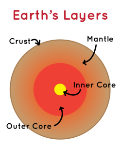
Earth is made up of four layers. The outermost layer is called the crust. The crust is made up rocks such as basalt and granite and it is very thin in comparison to the other layers. The crust is broken into many pieces called plates. There are two types of plates: continental plates and oceanic plates. Continental plates are much thicker than oceanic plates. Picture the depth of the ocean floor compared to the land; the ocean floor is much far below the land and, therefore, oceanic plates are thinner than continental plates.
The next layer is the mantle which is between the crust and core. This is the largest and thickest layer of Earth. The upper part of the mantle is made of magma; the tectonic plates float on this layer which is how they move.
Finally, Earth’s core is made of two layers: the outer and inner core. The liquid outer core is mostly made of iron and nickel. It is incredibly hot, so the metals remain in a liquid state. The flow of the liquid metals creates Earth’s magnetic field which is why compasses always point north. Additionally, the magnetic field protects the planet from extreme weather and radiation in space. The solid inner core is also made of iron and nickel. However, this layer is solid because the materials are under intense pressure at the center of Earth. Scientists know that the inner core is solid because of how seismic waves from earthquakes travel through the interior of Earth. The waves are unable to travel straight through the layers; instead they are refracted or bent by the dense inner core, so scientists believe this layer is solid.
Video credit: “Structure of the earth” by Khan Academy is licensed under CC BY-NC-SA 3.0. Note: All Khan Academy content is available for free at khanacademy.org.
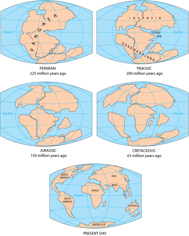
Pangaea
Due to plate tectonics, Earth’s land is constantly shifting and changing over time. 250 million years ago, all of Earth’s landmass was united in a single supercontinent called Pangaea. About 200 million years ago, this supercontinent began to break up into pieces as the plates moved away from each other. Smaller landmasses were formed until, eventually, the continents we recognize today were shaped. It is easy to see how certain continents, like South America and Africa, once fit together. Even today, the location of the continents continues to fluctuate. Scientists theorize that a new supercontinent, called Pangaea Proxima, could form 250 million years in the future.
Continental Drift
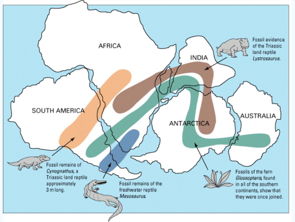
Proposed by scientist Alfred Wegener, the theory of continental drift was one of the earliest ways to explain why continents moved over time. Wegener noticed that the shape of Earth’s continents, such as South America and Africa, could fit together like a jigsaw puzzle. He also studied fossils from different continents that showed the remains of identical plants and animals spread throughout the world. For example, dinosaurs lived during the Triassic, Jurassic, and Cretaceous periods. As Pangaea broke into different pieces, fossils show that dinosaurs spread to different continents and evolved into different species over time. Based on this evidence, Wegener theorized that all of Earth’s continents were originally united in the supercontinent Pangaea. Over time, they drifted apart to their current positions.
While parts of this theory were correct, Wegener’s ideas had some flaws. For example, Wegener was unable to explain how the continents had separated over time. Consequently, this theory was replaced by the plate tectonics theory which is discussed in the next chapter, “Earth’s Structure: At the Surface and Underground”.

Key Takeaways
Timeline of Earth’s History:

Plate Tectonics
Plate tectonics explains how Earth’s plates move. Earth’s crust is divided into many plates which float on the molten upper layer of the mantle. This area is called the lithosphere. The movement of the plates is driven by convection currents in the mantle. Heat rises from the mantle and cools as it gets closer to the surface; from there, it sinks down where it is reheated and the cycle repeats. This creates a current that moves the plates. Although they are constantly moving, each plate moves very slowly–about 3 to 5 centimeters (1 to 2 inches) per year.
K-6 Standards
2-ESS1-1. Use information from several sources to provide evidence that Earth events can
occur quickly or slowly.
MS-ESS2-2. Construct an explanation based on evidence for how geoscience processes have
changed Earth’s surface at varying time and spatial scales.
MS-ESS2-3. Analyze and interpret data on the distribution of fossils and rocks, continental
shapes, and seafloor structures to provide evidence of the past plate motions.
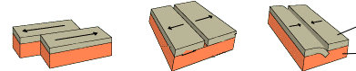
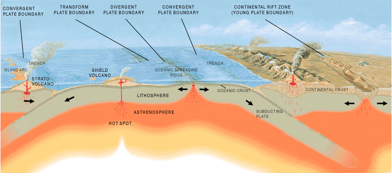
Tectonic Plate Boundaries
There are three types of tectonic plate boundaries:
- Transform boundary: plates sideswipe each other
- Divergent boundary: plates pull apart from each other
- Convergent boundary: plates push into each other
Transform, divergent, and convergent plate boundaries. “Plate tectonics” by USGS is public domain.
Depending on the type of tectonic plate and the type of plate boundary, different landforms can occur along plate boundaries.
- Convergent plates:
- When two continental plates converge, the land is pushed into each other and upward forming a mountain (however, it also pushes down into the mantle due to it being made of a liquid substance).
- When two oceanic plates converge, one plate is subducted under the other. In this situation, a trench or an island arc is formed.
- When a continental plate converges with an oceanic plate, the denser oceanic plate is subducted under the continental plate. As the oceanic plate is forced deeper underground, it reaches very high temperatures and melts into magma. Then, magma can rise up into the space and form volcanoes. This can also form a mountain range; for examples, the Andes mountains were formed in this way.
- Divergent plates
- In the ocean, magma rises up to fill the space between plates and a volcano is formed. When the material from the volcanic eruptions builds up over time, it forms a mid-ocean ridge.
- On land, a rift valley, or large crack is formed.
As seen in the map below, the Ring of Fire is an area in the Pacific Ocean bounded by several tectonic plates. Most of Earth’s earthquakes and volcanoes occur in this area due to the shifting of tectonic plates along these boundaries.
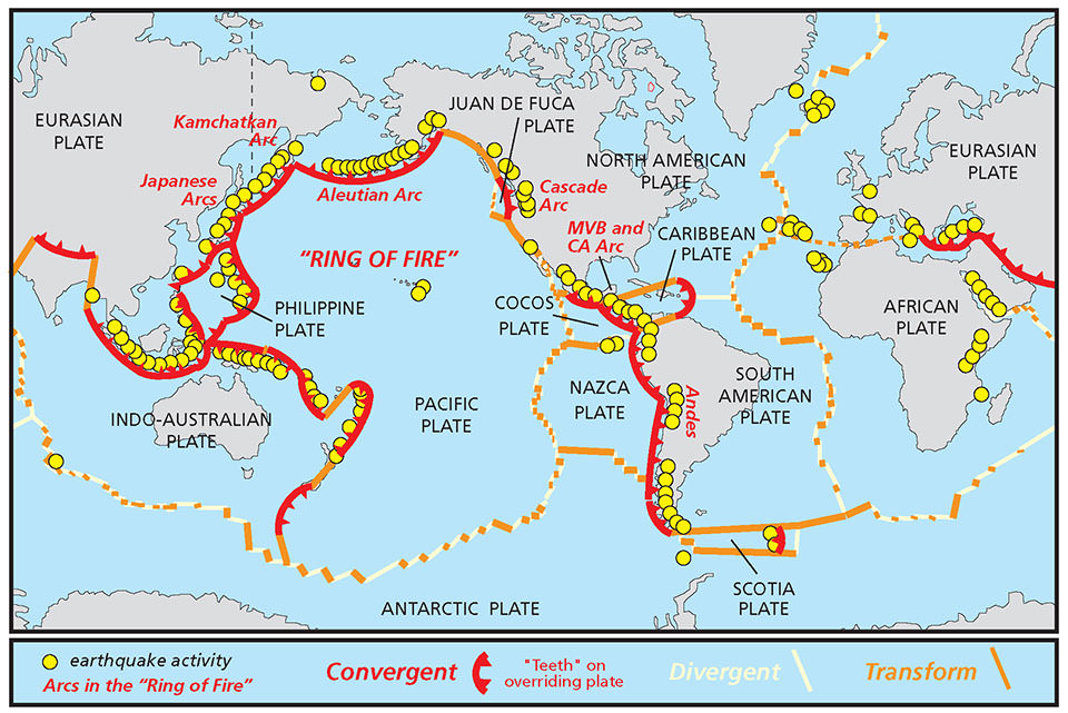 “Map of Tectonic Plates” by NOAA is public domain
Convection Cells
Convection takes place in the mantle and is the driving force behind plate tectonics. Molten rock that is heated rises to the surface, cools when it hits the air, and flows back down into the hot magma of the mantle once more. Essentially, the Earth recycles itself!

Connections to Standards:
2nd Grade
2-ESS1-1. Use information from several sources to provide evidence that Earth events can occur quickly or slowly.
6th – 8th Grade
MS-ESS2-3. Analyze and interpret data on the distribution of fossils and rocks, continental shapes, and seafloor structures to provide evidence of the past plate motions.
MS-ESS2-2. Construct an explanation based on evidence for how geoscience processes have changed Earth’s surface at varying time and spatial scales.
The outermost layer of Earth.
Less dense tectonic plates that make up the surface of land on Earth.
Denser tectonic plates that make up the ocean floor on Earth.
The middle layer of Earth between the crust and the core.
The innermost layers of Earth; made of a liquid outer core and a solid inner core.
Theory that Earth's crust is divided into many pieces, called tectonic plates, which move over time due to convection currents in the mantle.
A supercontinent made of all of Earth's landmass that existed 200-250 million years ago.
Theory that states that all of Earth's land was originally a united supercontinent that drifted apart over time. This theory was eventually replaced by the theory of plate tectonics.
