
16 Earth’s Structure: At the Surface and Underground
Layers of Earth
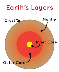
Earth is made up of four layers. The outermost layer is called the crust. The crust is made up rocks such as basalt and granite and it is very thin in comparison to the other layers. The crust is broken into many pieces called plates. There are two types of plates: continental plates and oceanic plates. Continental plates are much thicker than oceanic plates. Picture the depth of the ocean floor compared to the land; the ocean floor is much far below the land and, therefore, oceanic plates are thinner than continental plates.
The next layer is the mantle which is between the crust and core. This is the largest and thickest layer of Earth. The upper part of the mantle is made of magma; the tectonic plates float on this layer which is how they move.
Finally, Earth’s core is made of two layers: the outer and inner core. The liquid outer core is mostly made of iron and nickel. It is incredibly hot, so the metals remain in a liquid state. The flow of the liquid metals creates Earth’s magnetic field which is why compasses always point north. Additionally, the magnetic field protects the planet from extreme weather and radiation in space. The solid inner core is also made of iron and nickel. However, this layer is solid because the materials are under intense pressure at the center of Earth. Scientists know that the inner core is solid because of how seismic waves from earthquakes travel through the interior of Earth. The waves are unable to travel straight through the layers; instead they are refracted or bent by the dense inner core, so scientists believe this layer is solid.
Video credit: “Structure of the earth” by Khan Academy is licensed under CC BY-NC-SA 3.0. Note: All Khan Academy content is available for free at khanacademy.org.
Plate Tectonics
Plate tectonics explains how Earth’s plates move. Earth’s crust is divided into many plates which float on the molten upper layer of the mantle. This area is called the lithosphere. The movement of the plates is driven by convection currents in the mantle. Heat rises from the mantle and cools as it gets closer to the surface; from there, it sinks down where it is reheated and the cycle repeats. This creates a current that moves the plates. Although they are constantly moving, each plate moves very slowly–about 3 to 5 centimeters (1 to 2 inches) per year.
K-6 Standards
2-ESS1-1. Use information from several sources to provide evidence that Earth events can
occur quickly or slowly.
MS-ESS2-2. Construct an explanation based on evidence for how geoscience processes have
changed Earth’s surface at varying time and spatial scales.
MS-ESS2-3. Analyze and interpret data on the distribution of fossils and rocks, continental
shapes, and seafloor structures to provide evidence of the past plate motions.
Tectonic Plate Boundaries
There are three types of tectonic plate boundaries:
- Transform boundary: plates sideswipe each other
- Divergent boundary: plates pull apart from each other
- Convergent boundary: plates push into each other
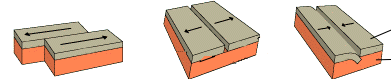
Transform, divergent, and convergent plate boundaries. “Plate tectonics” by USGS is public domain.
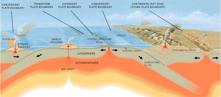
Depending on the type of tectonic plate and the type of plate boundary, different landforms can occur along plate boundaries.
- Convergent plates:
- When two continental plates converge, the land is pushed into each other and upward forming a mountain (however, it also pushes down into the mantle due to it being made of a liquid substance).
- When two oceanic plates converge, one plate is subducted under the other. In this situation, a trench or an island arc is formed.
- When a continental plate converges with an oceanic plate, the denser oceanic plate is subducted under the continental plate. As the oceanic plate is forced deeper underground, it reaches very high temperatures and melts into magma. Then, magma can rise up into the space and form volcanoes. This can also form a mountain range; for examples, the Andes mountains were formed in this way.
- Divergent plates
- In the ocean, magma rises up to fill the space between plates and a volcano is formed. When the material from the volcanic eruptions builds up over time, it forms a mid-ocean ridge.
- On land, a rift valley, or large crack is formed.
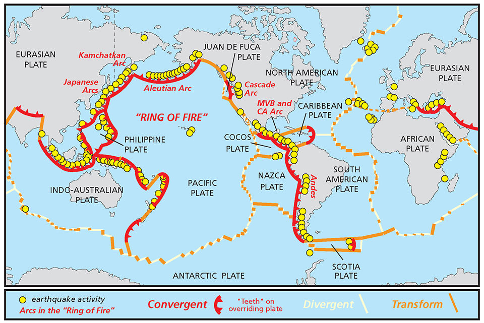
As seen in the map below, the Ring of Fire is an area in the Pacific Ocean bounded by several tectonic plates. Most of Earth’s earthquakes and volcanoes occur in this area due to the shifting of tectonic plates along these boundaries.
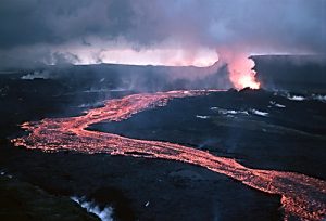
Volcanoes
A volcano is a vent that allows magma, rock fragments, ash, and gases to escape to the surface of a planet or moon. Volcanoes have created more than 80% of Earth’s surface. Volcanoes are found on every continent and on the sea floor in Earth’s oceans, as well as on several planets and moons in space.
When the material (magma, ash, and gases) from a volcano comes to Earth’s surface, it is called an eruption. There are two different types of volcanic eruptions: explosive and effusive. Explosive eruptions are when the magma is fiercely fragmented and rapidly expelled from a volcano. Effusive eruptions are when lava steadily flows out a volcano onto the ground.
- lava steadily flows out a volcano onto the ground
- occurs when magmas reaches the surface
- builds up gentle sloping shield volcanoes
- the magma is fiercely fragmented and rapidly expelled
- occurs where cooler magmas reaches the surface
- builds up steep sloping composite volcanoes
How Volcanoes are Formed
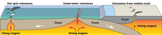
Volcanoes form when magma from deep within Earth rises to the surface. Volcanoes can be formed in 3 ways: converging tectonic plates, diverging tectonic plates, or over a hot spot.
- Convergent plates
When an oceanic plate converges with a continental plate, the oceanic plate subducts under the continental plate forming a subduction zone. At this zone, the denser plate is pushed under the other and the rock melts under intense heat and pressure as it is pushed further into Earth. Thus, the melted rock turns to magma and is able to rise to Earth’s surface as a volcano.
- Divergent plates
When two plates diverge, magma rises up to fill the space in between and an underwater volcano forms.
- Hot spots
A hot spot is an extremely hot area in the mantle where magma can rise up to the surface and create volcanic activity. The heat comes from deep within Earth, melting rock at the crust and forming magma. More typically, volcanoes occur along plate boundaries, but hot spots are located in the middle of tectonic plates. Yellowstone National Park in Wyoming is a supervolcano located over a hot spot. It hasn’t erupted for 174,000 years and is not expected to erupt soon. However, features in the park such as the geyser Old Faithful are fueled by volcanic activity over the hot spot.
The Hawaiian Islands, an island arc, were also formed by hot spot volcanoes on the Pacific Plate. The Pacific Plate is slowly moving northwest over time while the hot spot stays in the same place. As such, different areas of the plate are located over the hot spot at different times. Material from underwater volcanic eruptions at the hot spot builds up until it eventually reaches the surface, forming an island.
Based on the ages of rocks found on the islands, scientists can determine that the westernmost island, Kauai, is the oldest. 5 million years ago, Kauai was located over the hot spot. As the Pacific Plate shifted west, new islands in the chain were formed. Therefore, the easternmost island, the Big Island, is the youngest island and it is currently located over the hot spot. Eventually, new islands will continue to form in Hawaii. Scientists have detected a the beginnings of a new island, named Loihi, located southwest of the Big Island. Although it is currently located far below the ocean surface, volcanic eruptions have started to form Loihi and it will reach the surface in tens of thousands of years.
Video credit: “Hawaiian Islands Formation” by Khan Academy is licensed under CC BY-NC-SA 3.0. Note: All Khan Academy content is available for free at khanacademy.org.
Earthquakes
Tectonic plates float on the mantle, the layer below the crust. Breaks in the rock of the plates are called faults; these can occur in the form of plate boundaries as well as smaller cracks on the interior of plates. The rock moves along these fault lines at transform boundaries. Sometimes, however, they are unable to easily pass. The plates continue to push into or slide past each other which causes intense stress to build up. Eventually, the rocks will snap and the pressure will be released in the form of powerful seismic waves. This causes the ground to shake–an earthquake.
Law of Superposition
The Law of Superposition states that deeper layers of rock are older; deeper layers of rock were formed before layers that are closer to the surface. The Law of Original Horizontality states that successive layers of rock are formed in flat, horizontal layers; this is because gravity pulls down on the rock when it forms. Using these laws, geologists and archaeologists can determine the relative age the layers of rocks.
Sometimes, however, layers of rock do not match up horizontally. Due to the movement of Earth’s plates, the layers constantly shift and may become skewed or tilted. Additionally, surface level factors such as erosion and weathering can affect the top layer of earth by washing parts of it away. Finally, intrusions of magma (which forms igneous rock) can disrupt the horizontal layers beneath the surface. All of these factors provide clues for scientists to understand what occurred and when it happened at different times on Earth.
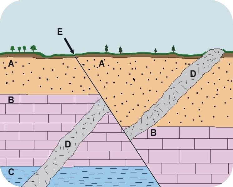
In the image, above, the layers of rock oldest to youngest are C, B, A, D.
- C is the oldest because it is the deepest layer.
- Next, B was formed on top of C.
- Then, A was formed on top of B.
- D is an intrusion of magma. We can tell it happened after A, B, and C were formed because it intrudes through all three layers and reaches the surface of Earth.
- Finally, a shift occurred in the layers due to plate tectonics, represented by the line, E. We can tell this happened last because every layer of rock and the intrusion have been disrupted and they are skewed horizontally.
K-6 Standards
4-ESS1-1. Identify evidence from patterns in rock formations and fossils in rock layers to
support an explanation for changes in a landscape over time.
To learn more about the Law of Superposition, the following video is highly-recommended viewing:
Video credit: Law of Superposition by Bozeman Science is licensed under CC BY 3.0
Fossils
Fossils are the remains of plants or animals that have been preserved in rock. Fossils form when the remains of a plant or animal are quickly buried after they die. Over time, the remains are replaced by minerals and compacted between layers of sediment to form fossils in sedimentary rock. Fossils are very fragile so they can only be found in sedimentary rocks; the extreme heat and pressure needed to form igneous and metamorphic rocks would destroy the fossil.
Fossils can also tell a story. Using the Laws of Superposition and Original Horizontality, geologists can figure out the relative age of a certain layer of rock. Sometimes, a specific type of fossil is found widely throughout one of these horizontal layers. Scientists can infer, then, that the organism lived during the same geologic time; this is called an index fossil. If the same type of fossil is found in other areas of rock, scientists can figure out that certain layers of rock were formed at the same time as well. In this way, fossils are a record of geologic time that tell a story to the people who find them.
K-6 Standards
3-LS4-1. Analyze and interpret data from fossils to provide evidence of the organisms and the
environments in which they lived long ago.
NGSS
| 5-ESS2-1. | Develop a model using an example to describe ways the geosphere, biosphere, hydrosphere, and/or atmosphere interact. [Clarification Statement: Examples could include the influence of the ocean on ecosystems, landform shape, and climate; the influence of the atmosphere on landforms and ecosystems through weather and climate; and the influence of mountain ranges on winds and clouds in the atmosphere. The geosphere, hydrosphere, atmosphere, and biosphere are each a system.] [Assessment Boundary: Assessment is limited to the interactions of two systems at a time.] |
|---|
| MS-ESS2-1. | Develop a model to describe the cycling of Earth’s materials and the flow of energy that drives this process. [Clarification Statement: Emphasis is on the processes of melting, crystallization, weathering, deformation, and sedimentation, which act together to form minerals and rocks through the cycling of Earth’s materials.] [Assessment Boundary: Assessment does not include the identification and naming of minerals.] |
|---|
| MS-ESS1-4. | Construct a scientific explanation based on evidence from rock strata for how the geologic time scale is used to organize Earth’s 4.6-billion-year-old history. [Clarification Statement: Emphasis is on how analyses of rock formations and the fossils they contain are used to establish relative ages of major events in Earth’s history. Examples of Earth’s major events could range from being very recent (such as the last Ice Age or the earliest fossils of homo sapiens) to very old (such as the formation of Earth or the earliest evidence of life). Examples can include the formation of mountain chains and ocean basins, the evolution or extinction of particular living organisms, or significant volcanic eruptions.] [Assessment Boundary: Assessment does not include recalling the names of specific periods or epochs and events within them.] |
|---|
| MS-ESS2-2. | Construct an explanation based on evidence for how geoscience processes have changed Earth’s surface at varying time and spatial scales. [Clarification Statement: Emphasis is on how processes change Earth’s surface at time and spatial scales that can be large (such as slow plate motions or the uplift of large mountain ranges) or small (such as rapid landslides or microscopic geochemical reactions), and how many geoscience processes (such as earthquakes, volcanoes, and meteor impacts) usually behave gradually but are punctuated by catastrophic events. Examples of geoscience processes include surface weathering and deposition by the movements of water, ice, and wind. Emphasis is on geoscience processes that shape local geographic features, where appropriate.] |
|---|
| MS-ESS2-3. | Analyze and interpret data on the distribution of fossils and rocks, continental shapes, and seafloor structures to provide evidence of the past plate motions. [Clarification Statement: Examples of data include similarities of rock and fossil types on different continents, the shapes of the continents (including continental shelves), and the locations of ocean structures (such as ridges, fracture zones, and trenches).] [Assessment Boundary: Paleomagnetic anomalies in oceanic and continental crust are not assessed.] |
|---|
DCI
2nd Grade
ESS1.C: The History of Planet Earth
ESS2.B: Plate Tectonics and Large-Scale System Interactions
fourth grade
ESS1.C: The History of Planet Earth
ESS2.B: Plate Tectonics and Large-Scale System Interactions
fifth grade
ESS2.A: Earth Materials and Systems
Middle school
ESS1.C: The History of Planet Earth
ESS2.A: Earth’s Materials and Systems
ESS2.B: PLate Tectonics and Large-Scale System Interactions
Crosscutting Concepts
Second grade
Patterns
Stability and Change
fourth grade
Patterns
Cause and Effect
Fifth grade
Scale, Proportion, and Quantity
Systems and System Models
The outermost layer of Earth.
Less dense tectonic plates that make up the surface of land on Earth.
Denser tectonic plates that make up the ocean floor on Earth.
The middle layer of Earth between the crust and the core.
The innermost layers of Earth; made of a liquid outer core and a solid inner core.
Theory that Earth's crust is divided into many pieces, called tectonic plates, which move over time due to convection currents in the mantle.
Part of Earth made of the crust and the upper molten part of the mantle.
The border between two tectonic plates.
Tectonic plates push into each other.
When two tectonic plates converge, the denser plate is pushed under the other.
A long depression formed on the ocean floor from the convergence of two oceanic plates. Trenches are some of the deepest place on Earth's surface.
A chain of islands in the ocean in an arc shape. Formed by two convergent oceanic plates and volcanic eruptions.
A vent that allows magma, rock fragments, ash, and gases to escape to the surface of a planet or moon.
Tectonic plates pull apart from each other.
An underwater chain of mountains formed at a divergent plate boundary.
An area in the Pacific Ocean bounded by several tectonic plates. Due to tectonic activity along these plates, this area has a high number of earthquakes and volcanic eruptions.
The boundary between two convergent tectonic plates where one plate subducts under the other.
Molten rock beneath Earth's surface.
Break or crack in the plates on Earth's crust.
Tectonic plates sideswipe each other.
Deeper layers of rocks are older than layers closer to the surface.
Due to the pull of gravity, new rock is initially formed in flat, horizontal layers.
